Friday, October 18, 2013

Notch Lake, Stony Clove Notch, Phoenicia, NY, October 2013

Sometimes being outside isn't exercise of the body, but of the soul. My last experience on the Catskill trip was visiting Stony Clove Notch. I was tipped off to it by a passing reference in Scott Brown's book on New York waterfalls. Brown mentioned shooting photos at the lake was a good alternative to the waterfall hike he outlined, and he gave suggestions on how to frame the photo. While I never saw the lilypads he suggested focusing on, I found my own way. Mr. Brown and many other people are better photographers than I am, but the photo below gives me great pleasure.

Stony Clove Notch is a few miles north of the Town of Phoenicia on NY Route 214. The notch is a passage between the mountains Hunter and Plateau. At the foot of Hunter is Notch Lake, and on the edge of Notch Lake is a day use area and long-term parking lot for backpackers. A popular hiking trail, the Devil's Path, crosses the day use area.

Aside from one person asking for directions - his accent placed him as from the Bronx, so he was very lost indeed - I was alone. I lingered as the sky grew dark and the mist began to form. I hated to leave. I'd not climbed a mountain in the Catskills. I wanted to. I wanted to be atop Hunter or Slide or Halcott or... but it wasn't going to happen this trip. I'd fallen once, and I was bent like a question mark thanks to twisting my back the wrong way.

I delayed leaving as long as I could. But I had miles to travel before I slept, so I said "till we meet again" to Hunter and Plateau, and started the long drive to Pennsylvania and Pine Creek Gorge.

Labels: ,

Tacky Amish - East Branch Trail, Spartansburg, PA, August 2013

"That sounds like a bad television program" I said when my friend Troy told me about the Spartansburg Amish.

We were unloading our bikes from Troy's truck at the trailhead for the East Brach Trail, and Troy was unfolding odd stories about the local Amish community. His tale of Amish women dressing 'English' and going to bars at night sounded like a leg pull. But then I remembered the only known murder among these plain people occurred in this region. And then on this very trail there was the incident with the tacks....

Before I get to that, I should present the trail to you. The East Branch Trail is a work in slow progress, with a three some mile paved section above and below Spartansburg, and miles of unpaved, unprepared railroad right of way beyond that. This morning we rode the paved segment, after a good breakfast at an Amish-themed diner in Spartansburg.

The trail itself was flat, paved, and scenic. Troy was, as usual, much faster than me, and was at the trail end waiting for me when I arrived. One benefit of being slower is that I missed seeing the black bear that crossed the trail ahead of Troy. I enjoyed the trail, and if the trail folks get it extended, with either a paved or finished gravel surface, I'd gladly come back to ride it.

After we were back to the truck and done all the goofy stuff we do on the rare occasions we meet, Troy drove us a few miles away to a bridge. The climb from the road to the old railroad right of way was steep, but accessible to horses and buggies, as the slope showed. I huffed and puffed as I reached the top, and walked across the bridge. Troy was standing there taking photos.

"Remember the tacks, Neil? This is where it happened."

In 2005 the Rails to Trails Conservancy held its annual Greenway Sojourn, a group trip of day rides on rail trails in a given area, in western Pennsylvania. They began in Erie and had little trouble until they came to Spartansburg. Cyclists had to put up with Amish picketing the use of 'their' trail by English, and on the stretch of trail I was standing on the trail had been mined with carpet tacks. Reportedly there were two hundred flat tires and the organizers had to scramble to SAG all their riders back to camp. A web search brings up any number of photos of cyclists fixing flats and the Amish picketers.

The Amish complaint, as far as I can tell, is that paving the trail and promoting its use means they will have more problems with "English" using the trail. Such problems can range from photographing the Amish - they object to photographs of themselves because its allegedly worldly - to clogging up the trail obstructing their buggies. I don't find these objections to be reasonable. I've ridden on trails used by Amish and Mennonites in Lancaster and Indiana Counties in Pennsylvania and Holmes County in Ohio, and I've not seen buggies or bikes obstructed nor photographers harassing the Amish.

As you can imagine, a sect that shuns to the extent the Amish do can easily form into small exclusive groups, and it appears the Spartansburg Amish are a bitter and strange cell indeed. While conflicts between the Amish and the greater community are more common than one would believe from tourist brochures, most of them avoid rising to the level of trail terrorism. The Amish of Spartansburg have instead embraced it.


Labels: ,

Diamond Notch Trail, Lanesville, NY, October 2013

After my bad experiences hiking on the Tanbark Trail and riding on the Catskill Scenic Rail Trail, I wanted SOMETHING in the Catskills to go right. I knew I wasn't up to the challenge of the hikes to the Giant Ledges or to the top of Slide. Wanting to salvage something of the trip, I found what has been called the easiest hike in the Catskills - Diamond Notch Falls. It wasn't a peak, but it might be what I needed.

Diamond Notch Trail is an old forest road allowed to fall into trail use. The trailhead is a small pull off at the entrance to the trail on Greene County Route 6. The road dead ends at the trail, and so its only accessible by car from Route 42. The drive north from Shankaden, alongside Halcott Mountain, is scenic, and after a few miles you turn right onto County 6. After another seven miles the road becomes gravel and reaches the trail. I've put Lanesville in the subject line of the post only to give a landmark; don't expect anything resembling a town here.


The trail surface itself becomes a mix of small and medium sized stones and dirt. While it wasn't like hiking in Rocksylvania, I did have to employ more caution than I expected. The trail climbed on the left side of the West Kill, and I was delighted by the continuous series of cascades. Scott Brown in his book on New York waterfalls wrote that if you have all day and don't mind getting wet and bruised you should skip the trail and hike in the creek, and perhaps he is right. The stream is always below the trail and it involves a scramble to get to it. Hiking on the streambed would let you get many photos of the petite cascades.

After a mile I came to Diamond Notch Falls proper, a fifteen foot drop that was unfortunately a fraction of its spring runoff glory. However, the bridge that appeared in both guidebooks I consulted was gone. If I wanted to see the falls up close I either needed to enter the creek or approach from the other side, and without the bridge that meant scrambling down a twenty foot slope. I'd be nervous about doing so even if I hadn't been alone or had a stiff back from the fall the previous day. So I turned around, thwarted by the Catskills yet again. That said, it WAS  a pleasant two mile hike to the falls and back, and one day New York may replace the bridge.


Labels: ,

Sam's Point Preserve, NY, October 2013

My trip to New York State and Pine Creek Gorge was largely a disappointment. I fell on the Tanbark Trail, I drove for an hour to the Catskill Scenic Rail Trail and found it a mess, my hurt back limited what I could do in both the Catskills and the Endless Mountains, and finally heavy rain forced me home early. And then.....

Chris, my friend in New Jersey who led me up to the Raven's Horn in August, contacted me with a suggestion. His church's hiking group was leaving for a day on easy trails in the Shawangunk Mountains in New York the next morning. Was I free? Yes, I was. And the night sleeping in my own bed seemed to have taken much of the trouble out of my back. So at 8:30 AM I was in New Jersey ready to join the trip north.


This was my first hike with a large group in years, and it was a good experience. Caleb's Crew Hiking Club is a group based on the membership of Chris' church, of which he is pastor. The name of the group comes from the Book of Joshua in the Hebrew Bible. After years of faithful service to God, Caleb is still ready for more work. Caleb asks God, as the King James translators put it, "Now therefore give me this mountain...." 


Our "mountain" today would be relatively easy. Sam's Point Preserve was a hike of a little more than a half mile to the top and the overlooks. And it used "carriage roads" - the improved forest roads the "400" leading families of New York City used when they vacationed in this area. So while the hike was a climb, it was relatively easy. The six tenths of a mile to the top sped by. And speaking of speeding, for once in my life I was near to leading a parade. I'm used to being the slowest walker or hiker or cyclist, and I was leading at times. I slowed as we passed the side of the rock outcropping we would soon stand on top of. 


The first overlook at Sam's Point is two thirds of the way to the top. Already the view was spectacular - forest everywhere, and in the far distance to the north the edge of the Catskill Mountains. The ledges were enormously wide compared to the Raven's Horn and Pole Steeple in PA. And the view only improved as we climbed to the top. Again it was a climb, but not an arduous one. Either I am improving or the carriage road was no challenge to me.

The main overlook at Sam's Point has a low stone wall around the platform, but visitors aren't restricted to that area, and there are other attractions one can hike to - a waterfall and a series of caves, for instance. But we restricted ourselves to the overlook and nearby rock cliffs. The latter pushed my fear of heights hard, but I won, as you can see in the photo of my walking along the cliff edge. That portion of the cliffs is accessible from a trail through the forest of dwarf pine, which is but another attraction among many here. This first hike in the Shawangunks gave me what I'd been looking for, and couldn't find, in the Catskills.


After we came down from the mountain we had lunch and headed off to our second hike of of the day, Lake Minnewaska, which I'll cover in another post.

Labels: , ,

Thursday, October 17, 2013

Tanbark Trail, Phoenicia, New York, October 2013

I was full of enthusiasm for my first hike in the Catskills. It was a sunny day, the temperature was cool, and I was surrounded by mountains higher than those in Pennsylvania. I had batteries, a working camera, and a good attitude. I'd hiked up Hawk Mountain, Pole Steeple, and the Raven's Horn. How much trouble can this be?

Phoenicia, pumpkin spice soy latte capital of New York.
I'd chosen the Tanbark Trail based on a description in a brochure on hiking published by Ulster County. It had an overlook, was less than a mile long, and wasn't too far of a drive. And the brochure didn't describe the trail as difficult or technical.

I set off in high spirits. The trailhead is in the town of Phoenicia, which could be described as the Portland of the Catskills if Portland were five blocks long. I parked in front of the post office, laced up my shoes, grabbed my hiking poles, and headed off. First I crossed a small park, then over a wooden bridge at the entrance to the trail.

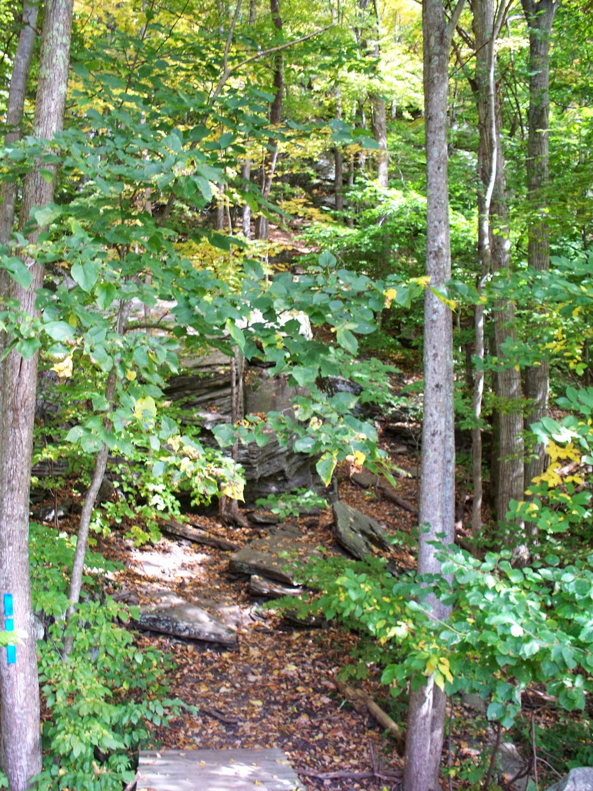
And then I saw the wall. The Tanbark climbs Mount Tremper, and it might as well have been a brick wall. It was all I could do to get my footing. It was plant one foot, plant both poles, bring the other foot up, check for timber rattlers, repeat. I am a slow hiker under normal circumstances, and as tough as the Raven's Horn was, this was tougher. And unlike the PA trail I didn't have two experienced hikers with me.

I got around the rock outcropping in the photo, and proceeded on to the next part of the climb. My shoes dug into the earth and I planted my poles. I reminded myself that I can do all things through Christ who strengthens me and I pushed on.

About now I became concerned about getting down. One of the members of the Caleb's Crew Hiking Club recently advised me that I needed to take "the next step" - that I'm a "big idea" person, that I like to see projects as a whole from beginning to end, and that the next step is to have faith - not just in God but in my abilities to complete a task. Finding the trail more difficult than I imagined, I doubted myself. And I doubted how to climb up the trail. Since the going was tough and the slope steep, I tried lowering myself to the ground and proceeding on all fours.

Pants by Cabela's, shoes by Brooks, socks by Wigwam.
My changed stance was a poor decision, and lasted only a few steps. By now I was so discouraged and full of doubt I decided to turn around and call it a day. The Tanbark could wait. I tried to back down the slope. I slipped, began to slide, and in the scramble to regain my footing wound up on my back and backside. My heels dug into the crumbling earth. I looked down, and decided crashing into the tree or the large rock beneath me would have been unpleasant. So I sat on the side of Mount Tremper while I caught my breath. While calming down I took a couple of photos and marveled at how tough my outdoor clothing is.

I'm estimating I was perched there for ten minutes, but it could have been less. I didn't cry for help because while its bad enough to abandon a hike a tenth of a mile into it, its worse to need help getting off the hike. While usually pride goes before a fall, in this case it came after.

Eventually three hikers wandered by above me. I called out to them.

"Good morning!"

"Good morning!"

"I was wondering if you might give me a hand here."

"What's the problem? Are you OK?"

"Oh, I'm OK, but I can't get up."

The lead hiker, Matt, hastened down the slope with the two ladies in his group. Matt and an older Russian woman took charge. They helped me slide down to the rock, stand up, and guided me back down the hill. Despite my seeming calm, I was nervous and embarrassed about the hike, and talked too much, I'm sure. But we got down safely, and Matt and the Russian woman - I never learned her name - posed for a photo with me. In the photo I look very short, but that's because they stood on the footbridge to the trail and I didn't.

I thanked my 'trail angels' and headed back to the car. Matt and the Russian woman were alternately full of encouragement and chiding - I deserved praise for pushing myself and hiking trails that would challenge me, and it was a poor choice to do such a difficult trail, and to attempt it alone.

At the time I was discouraged and down about the 'failed' hike, but looking back at a distance of two weeks gives me a different perspective. The comment made to me about the next step - having faith - seems to be key here. I knew I could hike the trail based on my experiences with others. But I doubted myself. I need to work on that, take the next step, and remain confident that I can do it. Self confidence is a bigger mountain to climb than Tremper, and I have no doubt that if I return to the Tanbark Trail I will be at the overlooks - standing up.


Labels: ,

A Taste For The Woods: 2013-10-13

This page has moved to a new address.

A Taste For The Woods