New York State of Mind - Hudson Valley Rail Trail and Walkway Over The Hudson, October 2013
I was down. My planned trip to Florida to visit my friend Sayre was scrapped for various reasons, and I was tentatively planning a "staycation."
However, my mood changed when a friend suggested I stay at a cabin they had purchased in the Catskill Mountains. I was surprised to discover the drive was no longer than the five hours I'd take to get to Pine Creek Gorge, for instance, and so I set about making plans. I've been to New York City twice as an adult, but aside from staying overnight at a friend's home in Buffalo I'd never been to New York State. I overplanned as usual and much of what I hoped to do was rewritten on the fly, but I got in the best experience largely as planned - the Walkway Over The Hudson.
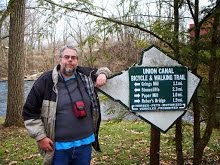
 The Walkway Over The Hudson is a lineal park, or what we ordinary folks might call a "trail", utilizing an old railroad trestle spanning the Hudson between Highland and Poughkeepsie. The bridge is one and a quarter miles long and the longest elevated pedestrian span in the world. Bikes are allowed on the bridge, and cyclists can avoid the day use fee the park charges by parking at trailheads on the adjoining trails in Highland or Dutchess County.

The colors of fall were around me. I took the tree colors on the trail as a sign of what I'd face in the Catskills. I felt like I was flying down the trail, passing the small road crossings and under a culvert. Before I expected it, I was at the bridge and riding the Walkway Over The Hudson.

 The bridge itself is wide, and while it was full of pedestrians and pets and cyclists 'traffic' was orderly and there were no near-misses or evasive actions that I could see. The view up and down the Hudson was spectacular, as was the elevated view of the city of Poughkeepsie. For people who want to stop and take in the view there are benches on both sides of the span. And should you tire of the Hudson the bridge is a great place for people-watching. The Walkway when I visited was used by all sorts of folks - commuters on foot and on bikes, people out for a stroll, roadies riding a loop .... and a formerly sedentary man from Pennsylvania rediscovering the outdoors.
I crossed into Dutchess County and began to ride on their extensive trail network. However, time demanded I turn around after a couple of miles. I still had to drive an hour into the Catskills and locate my friend's cabin, and I was advised to get there before dark lest I have trouble locating it. So I headed back to Highland and my car. My dozen miles on the trails and Walkway was the highlight of my trip, and I long to ride them again. And more importantly, I was no longer down. I was, indeed, idle no more.
Labels: Bicycling, New York State of Mind 2013
posted by The Historian @ 8:24 AM
0 Comments
![]()